17.05.060 Definitions.
For the purpose of carrying out the intent of this title, certain terms or words used herein shall be interpreted or defined as follows. Words used in the present tense include the future; words used in the singular include the plural; and words in the plural include the singular. The words “shall” and “will” are mandatory. The words “may” and “could” are permissive. The words “guidelines,” “provisions,” “standards” and “regulations” are used interchangeably and are mandatory. The following additional words and phrases shall, for the purpose of this title, have the following meanings:
“Abandonment, plat” means the intentional relinquishment of a vested plat for the purposes of re-platting the property into a different configuration or dividing up the property.
“Abandonment, right-of-way” means the intentional relinquishment of right-of-way and transferring rights of property to another owner.
“Abutting” means the condition of two adjoining properties having a common property line or boundary, including cases where two or more lots adjoin only at a corner(s).
“Accessory use” means a use, building, structure, part of a building, or part of a structure which is subordinate to, and the use of which is incidental to,the main building, structure or use on the same lot, including a private garage. If a building otherwise qualified as an accessory building is attached to the main building by a common wall or roof, such building shall be considered part of the main building.
“Air space” means the ownership or control of all land, property, and area of space at and above a horizontal plane over the ground surface of land defined by a survey and legal description of the lot. The horizontal plane shall be at a height that is reasonably necessary or legally required for the full and free use of the ground surface.
“Alley” means a right-of-way, dedicated to public uses, which gives a primary or secondary means of vehicular access to the rear or side properties otherwise abutting a street, and which may be used for utility access but is not intended for general traffic circulation.
“A.L.T.A.” means American Land Title Association.
“Applicant” means a property owner or any person or entity acting as an agent for the property owner or developer in an application for a development proposal, permit, or approval.
“As-builts” means construction or engineering plans prepared after construction which accurately identify the location of on-site or off-site improvements such as sidewalks, curb and gutter, retention areas, utilities, and landscaping.
“Basin, detention” means a storm water storage facility that temporarily stores surface runoff and releases it at a controlled rate through a positive outlet. A detention basin and park may be joined to serve both recreational needs and as a water storage facility (see design criteria in MCC 17.30.040 and 17.30.130).
“Basin, drainage” means a geographical area that contributes surface runoff to a particular concentration point. The terms “drainage basin,” “tributary area” and “watershed” are used interchangeably.
“Basin, retention” means a storm water storage facility that stores surface runoff. Stored water is infiltrated into the subsurface or released to the downstream drainage system or watercourse (via gravity outlet or pump), or evaporated after the storm event. A retention basin and park may be joined to serve both recreational needs and as a water storage facility (see design criteria in MCC 17.30.040 and 17.30.130).
“Berm” means an earthen mound, either natural or man-made.
“Bicycle lane” means a paved area located within a street right-of-way and within the pavement section that is designated for bicycle or other nonmotorized traffic.
“Bicycle path” means a paved area located within a street right-of-way but not between curbs that is designated for bicycle or other nonmotorized traffic.
“Block” means a piece or parcel of land or group of lots bounded by public or private streets and public land, railroad rights-of-way, state highway rights-of-way, washes, parks, or a combination thereof creating a physical barrier of sufficient magnitude as to interrupt the continuity of development.
“Board of adjustment” means the board of adjustment for the city of Maricopa.
“Buffer area” means an area of land, including landscaping, berms, walls and fences but not building setbacks, that is located between land uses of different character or density and is intended to mitigate negative impacts of the more intense use on residential or vacant parcels.
“Buildable” means a lot or parcel that has the area, shape, slope, street frontage, or other attribute in order for a permitted use, based on the lot or parcel’s zoning district, to be developed, without the need for any variance from MCC Title 18, Zoning.
“Building setback line” means the required minimum distance, as prescribed by MCC Title 18, Zoning, between the property line and the closest point of any building or structure.
“Bus stop” means a designated curbside area for embarking and disembarking of transit passengers. A small three-sided structure may be included to provide shelter for waiting passengers.
“Chord” means a straight line joining two points on a curve.
“City” means the city of Maricopa, Arizona.
“Cluster development” means a development pattern that concentrates development in specific areas on a site through a density transfer rather than distributed evenly throughout a parcel as in conventional lot-by-lot development with the remaining portion of the site retained as natural open space or parks.
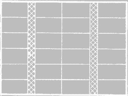
24 Conventional Lots
Minimum Open Space
24 Clustered Lots
50% Open Space
“Commission” means the planning and zoning commission of the city of Maricopa.
“Committee” means the technical advisory committee of the city of Maricopa.
“Conditional approval” means an affirmative action by the commission or council indicating approval will be forthcoming with satisfaction of certain specified conditions or stipulations.
“Condominium” means real estate, portions of which are designated for separate ownership of air space and the remainder of which is designated for common ownership solely by the owners of the separate portions. Real estate is not a condominium unless the undivided interests in the common elements are vested in the unit owners. The term “condos” may also be used in the ordinance.
“Conservation easement” is a permanent open space easement granted to the city or to a public land trust to limit or prohibit development of the property; to protect archaeological sites, ecologically significant lands, scenic highways, hiking trails, biking trails, equestrian trails, and; to preserve the land for the scenic enjoyment of the general public.
“Conventional development” means development other than a cluster development or a Planned Area Development (PAD).
“Council” means the city council of the city of Maricopa.
“County” means Pinal County, Arizona.
“Cut” means the removal of soil, rock, or other materials from a location which shapes and lowers the grade at the location.
“Department” means the development services – planning division of the city of Maricopa.
“Development” means the utilization of land for public or private purposes.
“Easement” means a grant by the owner of the use of land by the public, a corporation, or person for the specific uses designated.
“Engineer” means the city engineer of Maricopa or his designated representative.
“Exception” means any parcel of land that is not owned by the applicant or not included in the recorded plat. All such exceptions must be noted on the final plat as “not a part of this subdivision.”
“Figure” means any graphic representation noted as “Figure” within this title, that is used to illustrate and exemplify certain standards and regulations contained within the language of this title. If a figure and text of the title conflict, the written text of the ordinance shall control.
“Fill” means any soil, rock or other material, installed to raise the grade.
“Finished grade” means the final grade and elevation of the ground surface after grading is completed and in conformance with the approved grading plans.
“Flood hazard zone” means any land area partially or wholly within a delineated floodplain susceptible to flood related damage as designated on the flood management maps. Such flood hazard zones may include, but not be limited to, areas highly susceptible to erosion, stream meander sensitivity, moveable bed, scour, and subsidence.
“Floodplain” means low lands adjoining the channel of a river, stream or watercourse, lake or other body of water, which have been or may be inundated by floodwater, and those other areas subject to flooding. A floodplain may be an area further defined by the Drainage Policy of the city of Maricopa and as shown on Federal Emergency Management Agency (FEMA) flood insurance rate maps (FIRM) or an approved flood control study.
“Flood prone area” means any area within a floodplain.
“Floodway” means the channel of a wash or other watercourse and the adjacent land areas that must be reserved in order to discharge the 100-year flood without cumulatively increasing the water surface elevation more than one foot.
“General plan” means a voter ratified municipal document of the development policies and goals, which may include maps, charts, graphs and text which set forth objectives, principles and standards for local growth and redevelopment enacted under the provisions of A.R.S. § 9-461 et seq.
“Health department” means Pinal County Health Department.
“Homeowner’s/property owner’s association” means a nonprofit corporation or unincorporated association of owners created pursuant to a declaration of restrictions to own and operate portions of a planned community and which has the power under the declaration to assess association members to pay the costs and expenses incurred in the performance of the association’s obligations under the declaration.
“Improvements” means required installations, pursuant to this subdivision title and any zoning stipulations, including but not limited to: grading, sewer, water, utilities, streets, curbs, gutters, sidewalks, trails, alleys, street lights, traffic control devices and landscaping; as a condition to the approval and signing of the final plat, before recordation.
“Improvement plans” means a set of plans setting forth the profiles, cross-sections, details, specifications, instructions and procedures to be followed in the construction of public or private improvements in the city of Maricopa which are prepared and bear the seal of an Arizona-registered land surveyor, engineer, architect or landscape architect in accordance with the approved preliminary plat, and zoning stipulations, and in compliance with standards of design and construction that are to be approved by the city engineer, other city departments, the applicable county departments, and all applicable utilities.
“Improvements standards” means a set of regulations and exhibits setting forth the details, specifications and instructions to be followed in the design and construction of required improvements.
“Irrigation facilities” includes laterals, ditches, conduits, pipes, gates, pumps and allied equipment necessary for the supply, delivery and drainage of irrigation water and the construction, operation and maintenance of such.
“Landscape” includes vegetation and irrigation, hardscape, public art or a combination thereof that may be calculated as open space (refer to the definition of Open Space).
“Lot” means a single piece of property having frontage on a publicly dedicated and accepted street or a private road approved and accepted by the city and established by a plat, recorded subdivision or otherwise established by some legal instrument of record which is described and denoted as such.
“Lot area” means the area of a horizontal plane within the lot lines of a lot but not including any area in a public way.
“Lot combination” means the process to combine separate parcels or re-parcel lots.
“Lot corner” means the intersection of two or more lot lines, or angle point or change in direction of a lot line.
“Lot, corner” means a lot abutting on two or more intersecting streets where the interior angle of intersection does not exceed 135 degrees. A corner lot shall be considered to be in that block in which the lot fronts. Corner lots may also have a landscape tract between the lot and the road as required for open space and landscaping. (See above illustration). Corner lots are required a 10-foot landscape setback adjacent to the street side yard.
“Lot coverage” means the percentage of the area of a lot that is occupied by all buildings or other covered structures using the roof outline for all outer dimension, excluding overhangs less than two and one-half feet and pergolas, trellis, and other similar open-air structures.
“Lot depth” means the horizontal length of a straight line connecting the midpoints of the front and rear lot lines; and for triangular shaped lots, the shortest horizontal distance between the front lot line and a line within the lot, parallel to and at a maximum distance from the front lot line, having a length of not less than 10 feet.
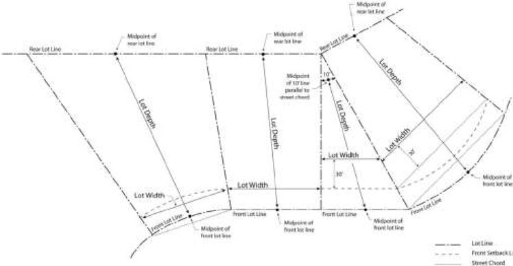
Lot Width and Depth
“Lot, flag” means a parcel of land taking access by a strip, owner of which lot or parcel of land has fee-simple title to said strip extending from the main portion of the lot or parcel of land to the adjoining street. (See above illustration).
“Lot improvement” means any building, structure, place, work of art or other object or improvement of the land on which they are situated constituting a physical betterment of real property.
“Lot, interior” means a lot other than a corner lot. (See above illustration)
“Lot, key” means a lot adjacent to a corner lot having the side lot line in common with the rear lotline of the corner lot and fronting on the street that forms the side boundary of the corner lot. (See above illustration 1.8).
“Lot line” means a line dividing one lot from another or from a street or any public place.
“Lot line, front” means in the case of an interior lot, a line separating the lot from the street right-of-way. In the case of a corner lot, the narrower of the two lot lines adjoining a street right-of-way.
“Lot line, rear” means a lot line which is opposite and most distant from the front lot line; except that in the absence of a rear lot line as is the case of the triangular shaped lot, the rear lot line may be considered as a line within the lot, parallel to and at a maximum distance from the front lot line, having a length of not less than 10 feet.
“Lot line, side” means the boundary of a lot that is not a front lot line or a rear lot line.
“Lot splits” means the division or re-division of improved or unimproved land or established lots, the area of which is two and one-half acres or less, into two or three tracts, parcels of land or lots for the purpose, whether immediate or future, of sale, lease, or conveyance (refer to the definition of Minor Land Division if greater than two and one-half acres in size).
“Lot, through” means a lot having a part of opposite lot lines abutting two streets, and which is not a corner lot (also known as a “double frontage lot”). On such lot, both lot lines are front, except that where a nonaccess easement has been established on such a lot, the front lot line shall be considered as that lot line most distant from the lot line containing the non-access easement. (See previous illustration).
“Lot width” means the horizontal distance between the side lot lines, measured at right angles to the lot depth. Minimum lot width is measured perpendicular to the lot depth at both the front and rear setbacks.
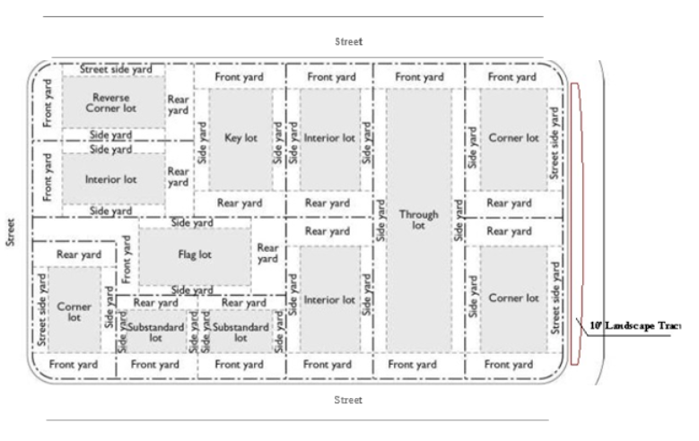
Lot and Yard Types
“Map of dedication” means the form of subdivision plat that dedicates right-of-way and/or easements and is processed as a minor subdivision.
“Minor land division” means the division of improved or unimproved land, the area of which is greater than two and one-half acres and either requires creating a road and/or the land does not constitute a subdivision, as defined herein or by Arizona Revised Statutes, due to the size of the original parcel or number of lots being created for the purpose, whether immediate or future, of sale, lease, or conveyance(refer to the definition of Lot Splits if less than two and one-half acres in size).
“Mixed-use development” means a building or group of buildings developed for residential uses that are integrated with nonresidential uses such as, but not limited to, office, retail, service, commercial, public, or entertainment, in a compact urban form.
“Natural features, significant” includes washes, significant vegetation, and significant rock outcroppings provided these features are in their undisturbed natural state.
“Natural grade” means the undisturbed natural surface of the land, including washes. On lots that have been disturbed previously, the natural grade is the preexisting grade if it can be determined; otherwise it shall be determined by an average of on-site elevations at points taken around the boundary of the site.
“Natural wash, desert” means any creek, stream, wash, channel, or other body of water having historical banks and with a flow rate equal to or greater than two cubic feet per second based on a 100-year storm event.
“Net acres” means the total acreage of a tract or parcel of land exclusive of arterial or collector street right-of-way dedications and school/public site reservations. When calculating residential net acres within a Planned Area Development (PAD), any multifamily, commercial, or industrial land use must be excluded in addition to those uses listed above.
“Off-site” means not located within the area of the property to be developed.
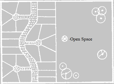
“Open space” means any parcel or area of land or water, natural or improved and set aside, dedicated, designated, or reserved for the use and enjoyment of all the residents of the development or the public in general. Open space does not include vacant or undeveloped lots, bike lanes or sidewalks attached to the back of the curb.
“Open space, common” means open space usable by all people within a certain development and such area is owned in common by all property owners in that development.
“Open space, natural area (NAOS)” means open space areas required for the preservation and conservation of plant and animal life, including habitat for wildlife species.
“Open space, public” means an open space area conveyed or otherwise dedicated to a municipality, municipal agency, state or county agency, or other public body for recreational or conservational uses.
“Open space, usable” means land which can be enjoyed by people. This could include landscaped or hardscaped plazas, paseos, promenades, fountains, and sitting areas meant to provide an open park-like atmosphere. Also natural areas, landscaped buffers, landscaped retention basins if designed in accordance with specific open space standards, playgrounds, , bicycle trails (but not bike lanes), pedestrian trails (not residential sidewalks), trail heads and parks. (See MCC 17.30.040 for more information.)
“Owner” means the person or persons holding title by deed to land, or holding title as vendor under a land contract, or holding any other title of record.
“Parks” means a public/private tract of land that contains a mix of active and passive recreation facilities including for example but not limited to tot lots, defined and improved play fields and/or sport court areas, and/or other recreational components, and picnic/seating/shade areas that are landscaped/hardscaped in a pleasing manner.
Patio Home. See Townhouse.
“Pedestrian way” means a public walk dedicated entirely through a block from street to street and/or providing access to a school, park, recreation area, trail system, or shopping area.
“Planned Area Development (PAD)” means a development with a minimum of 10 acres or more all of which must be contiguous, in which flexibility can be sought in the zoning standards, in order to encourage cluster development or more creativity and sustainable design, thereby providing usable open spaces within and about the development and enhancing the residential character of the city. Planned Area Developments shall be subject to planning commission review and recommendation and city council approval.
“Plat” means a map that provides for changes in land use or ownership.
A. “Preliminary plat” means a tentative map, including supporting data, indicating a proposed subdivision design, prepared by a registered civil engineer, or a registered land surveyor, in accordance with this title and the Arizona Revised Statutes. A preliminary site plan for a condominium development shall be considered a preliminary plat.
B. “Final plat” means a final map of all or part of a subdivision, including supporting data, in substantial conformance to an approved preliminary plat and all stipulations or conditions placed upon it by the council, prepared by a registered land surveyor, in accordance with this title and the Arizona Revised Statutes.
C. “Recorded plat” means a final plat bearing all certificates of approval required by this title and the Arizona Revised Statues and duly recorded in the Pinal County Recorder’s office.
D. “Reversionary plat” means:
1. A plat for the purpose of reverting previously subdivided acreage to unsubdivided acreage; or
2. A plat for the purpose of vacating rights-of-way previously dedicated to the public and abandoned under procedures prescribed by the city code; or
3. A plat for the purpose of vacating or redescribing lot or parcel boundaries previously recorded.
“Pre-application meeting” means an initial meeting between the applicant and municipal representatives that affords the applicant the opportunity to present their proposals informally and discuss the project and address any items before the rezone or preliminary plat application is submitted.
“Preliminary approval” means affirmative action on a preliminary plat, noted upon prints of the plat, indicating that approval of a final plat will be forthcoming upon satisfaction of specified stipulations; and which constitutes authorization to submit final engineering plans and the final plat.
“Private access way” means a private way of access dedicated as a tract to one or more lots or air spaces, which has been improved in accordance with city standards and plans approved by the city engineer.
“Protected development rights plan” means a final subdivision plat that meets all the requirements of this title and A.R.S. § 9-463.01, and which has been recorded with the county recorder shall constitute a protected development rights plan.
“Public utility easement (PUE)” means land, which by conveyance of easement is dedicated for public use of a utility line and associated appurtenances.
“Public services department” means the public services department of the city of Maricopa.
“Recorder” means the recorder of Pinal County.
“Recreation facilities” means planned areas for public or private use for residents and guests to enjoy activities within a development, such as but not limited to parks, tot lots, golf courses, swimming pools, and community centers.
“Right-of-way” means any public or private access way required for ingress or egress, including any area required for public use pursuant to any official plan; rights-of-way may consist of fee title dedications or easements.
“Roadway easement” means a recorded conveyance to the public over a described area for roadway related uses.
“Service easement” means an area provided for in the subdivision design, commercial or multi-family dwelling use of sufficient size and accessibility to facilitate the provision of necessary services.
“Sidewalk” means a hard surfaced path, course, route, track, or footway constructed of but not limited to: concrete, asphalt, decomposed granite or decorative pavers.
“Sidewalk, attached” means a sidewalk adjacent to a street or curb, not separated by a strip of landscaping or pavers.
“Sidewalk, detached” means a sidewalk separated from the street or curb by a strip of landscaping or pavers.
“Sketch plan” means a preliminary presentation of a proposed subdivision or site plan of sufficient accuracy to be used for discussion purposes and identification of any items of controversy or issues of concern.
“Staging area” is a trailhead specifically designed to accommodate equestrians. It includes areas for horse trailer parking, and facilities for hitching, mounting, and watering horses.
Street, Arterial. “Arterial streets” provide a high level of mobility for city-wide through traffic movement and are typically spaced at one-mile or greater intervals, have limited access, and no on-street parking. Design standards can be found in the city of Maricopa Design Standards Manual.
Street, Collector. “Collector streets” provide mobility and access and link the arterial and local roadways as well as allowing access to adjacent properties. Design standards can be found in the city of Maricopa Design Standards Manual.
“Street, cul-de-sac” means a local street having one end permanently terminated in a vehicular turnaround, or an equally convenient form of turning, and backing areas as may be recommended by the city engineer. Design standards can be found in the city of Maricopa Design Standards Manual.
“Street, frontage” means a local street parallel to an arterial or collector road which intercepts the residential traffic and controls access to the arterial and collector roads. Design standards can be found in the city of Maricopa Design Standards Manual.
“Street, local” provides for direct access to residential or other abutting land and serve local traffic movement with connections to roadways of higher classification. Design standards can be found in the city of Maricopa Design Standards Manual.
“Street, private” means any road or street that is not publicly owned and maintained providing access to lots or units over a common parcel.
“Subdivision” means improved or unimproved land or lands divided for the purpose of financing, sale, lease, or conveyance whether immediate or future, into four or more lots, tracts or parcels of land; or, if a new street is involved, any such property which is divided into two or more lots, tracts or parcels of land, or, any such property, the boundaries of which have been fixed by a recorded plat, which is divided into two or more parts. “Subdivision” also includes any condominium, cooperative, townhouse, patio home, or similar project containing four or more parcels, in which an undivided interest in the land is coupled with the right of exclusive occupancy of any unit located thereon.
“Subdivision” does not include the following:
a. The sale or exchange of parcels of land between adjoining property owners if such sale or exchange does not create additional lots.
b. The partitioning of land in accordance with other statutes regulating the partitioning of land held in common ownership.
c. The leasing of apartments, offices, stores or similar space within a building or trailer park, nor to mineral, oil, or gas leases.
“Technical advisory committee” means the selected group of technically qualified individuals, appointed by the administrator, made up of city staff and other public or private agencies and utility company representatives responsible to ensure compliance with city ordinances, codes and standards as they relate to the subdivision process.
“Technical review” means the detailed review of proposed preliminary plats, by the technical advisory committee, for compliance with city codes, ordinances, standards, or conditions of approval by the commission or city council. Other utilities and public agencies are invited to review the plat as it relates to their conditions of service or need.
“Time-share” means a right of occupancy in a time-share project, which is owned, occupied, or possessed, under either interval ownership or fractional fee interests as may be determined by the city council.
“Tot lot” means an improved and equipped play structure primarily for small children, usually no older than elementary school age.
“Townhouse” means a building on its own separate lot containing one dwelling unit occupying space from the ground to the roof, and is attached to one or more other townhouse dwelling units by at least one common wall. Shall also mean patio home.
“Trail, multi-use” means a hard-surfaced trail designed for all types of nonmotorized use.
“Trail, pedestrian” means a paved or improved surfaced trail, which may be located inside or outside of a street right-of-way, utilized for bicycle, pedestrian or other nonmotorized traffic.
“Trail, unpaved” means a designated trail designed to accommodate primarily equestrians, off-road bicycles, and pedestrian users.
Trailhead. A “trailhead” serves as the beginning point of a trail and must be ADA accessible and include parking, trail information and may also include trash receptacles, water, sanitary facilities and shade structures/ramadas.
“Usable lot area” means that portion of a lot usable for, or adaptable to, the normal uses made of property, excluding any areas which may be covered by water, are excessively steep, or are included in certain types of easements. Areas covered by water shall include areas within the defined floodplain, flood prone areas, or are within the perimeter of a given body of water that will remain after the development is completed.
“USC&GS” means United States Coast and Geodetic Survey.
“USACOE” means United States Army Corps of Engineers.
“Utility services” means service to the public of water, sewer, gas, electricity, telephone and cable television. The foregoing shall be deemed to include facilities and appurtenances to the above uses but shall not include public utility treatment and generating plants or offices.
“View fencing (view fence)” means shall mean fencing that is constructed in such a manner as to achieve between 30 percent and 80 percent overall openness.
“Watercourse” means any lake, river, stream, creek, wash, arroyo, or other body of water or channel having banks and bed through which waters flow at least periodically.
“Water supply, assurance (100 years)” means a certificate of assured water supply when land is divided into six or more parcels; written statement that the water supply and flows to the subdivision are adequate and in accordance with city and the fire department requirements and provides evidence that it meets the Arizona Department of Water Resources requirements for a 100-year assured supply.
“Workforce housing” means the base price of the housing is affordable, according to the Federal Department of Housing and Urban Development, for either homeownership or rental, and that it is occupied, reserved, or marketed for occupancy by households with a gross income that is greater than 50 percent but does not exceed 80 percent of the median gross household income for households of the same size within the city of Maricopa, as determined by the latest U.S. Census information.
“Zone” means a district classification established by MCC Title 18, Zoning, that limits or permits various and specific uses.
“Zoning administrator (administrator)” means the zoning administrator for the city of Maricopa or her/his representative.
“Zoning clearance” means the approval by the zoning administrator of a plan that is in conformance with MCC Title 18, Zoning.
“Zoning district” means a zoned area in which the same zoning regulations apply throughout the district.
“Zoning code” means MCC Title 18, Zoning. [Ord. 20-11 §2(14-1-6); Res. 20-31.]