18.15.030 Rules for measurement.
The purpose of this section is to explain how various measurements referred to in this code are to be calculated.
A. Applicant’s Responsibility. For all calculations, the applicant shall be responsible for supplying drawings illustrating the measurements that apply to a project. These drawings shall be drawn to scale and of sufficient detail to allow easy verification upon inspection by the zoning administrator.
B. Fractions. Whenever this code requires consideration of distances, parking spaces, dwelling units, or other aspects of development or the physical environment expressed in numerical quantities, and the result of a calculation contains a fraction of a whole number, fractions of one-half or greater shall be rounded up to the nearest whole number and fractions of less than one-half shall be rounded down to the nearest whole number, unless an alternate rule for rounding is specified by the same section of this code that describes the requirement.
C. Measuring Distances.
1. Measurements Are Shortest Distance. When measuring a required distance, such as the minimum distance between a structure and a lot line, the measurement is made at the closest or shortest distance between the two objects.
2. Distances Are Measured Horizontally. When determining distances for setbacks and structure dimensions, all distances are measured along a horizontal plane from the appropriate line, edge of building, structure, storage area, parking area, or other object. These distances are not measured by following the topography or slope of the land.
3. Measurements Involving a Structure. Measurements involving a structure are made to the closest exterior support wall of the structure. Structures or portions of structures that are entirely underground are not included in measuring required distances, unless otherwise specified in this code (gas tanks, swimming pools, etc.).
4. Measurement of Vehicle Stacking or Travel Areas. Measurement of a minimum travel distance for vehicles, such as garage entrance setbacks and stacking lane distances, are measured down the center of the vehicle travel area. For example, curving driveways and travel lanes are measured along the center arc of the driveway or traffic lane.
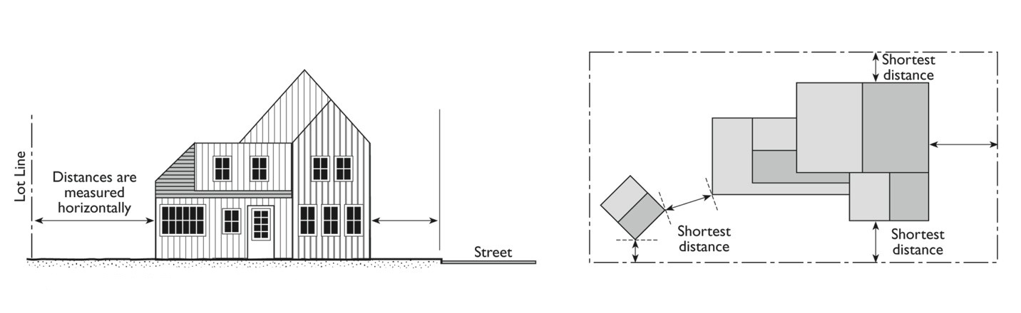
Figure 18.15.030.C. Measuring Distances
D. Measuring Radius. When a specified land use is required to be located a minimum distance from another land use, the minimum distance is measured in a straight line at the closest point of the two lot lines. Where a specific use within this code provides a conflicting rule of measurement, the specific use regulation shall control.
E. Measuring Height.
1. Measuring Building Height. Building height is the vertical distance measured from the natural grade to the highest point of the structure directly above the natural grade when such structure is not located on a platted subdivision. If the structure is located in a platted subdivision, height shall be the vertical distance measured from the finished grade as shown on the subdivision grading plans or finished grade as shown on the individual lot’s grading plan (whichever is lower) to the highest point of the structure directly above the finished grade.
2. Measuring Height of Other Structures. The height of other structures, such as fences, is the vertical distance from the finished grade immediately under the structure to the top of the structure. Special measurement provisions are also provided below.
a. Measuring the Height of Fences on Retaining Walls. The height of a solid freestanding fence that is on top of a retaining wall is measured from the ground level on the lowest side of the combined fence and wall. If the freestanding portion of the wall is set back from the retaining wall a distance equal to or greater than the height of the freestanding portion of the wall, the retaining and freestanding wall heights shall be calculated separately as individual walls. The setback area shall be landscaped in a manner to soften the combined wall mass. View fence is exempt from this requirement.
b. Measuring the Height of Decks. Deck height is determined by measuring from the ground to the top of the floor of the deck.
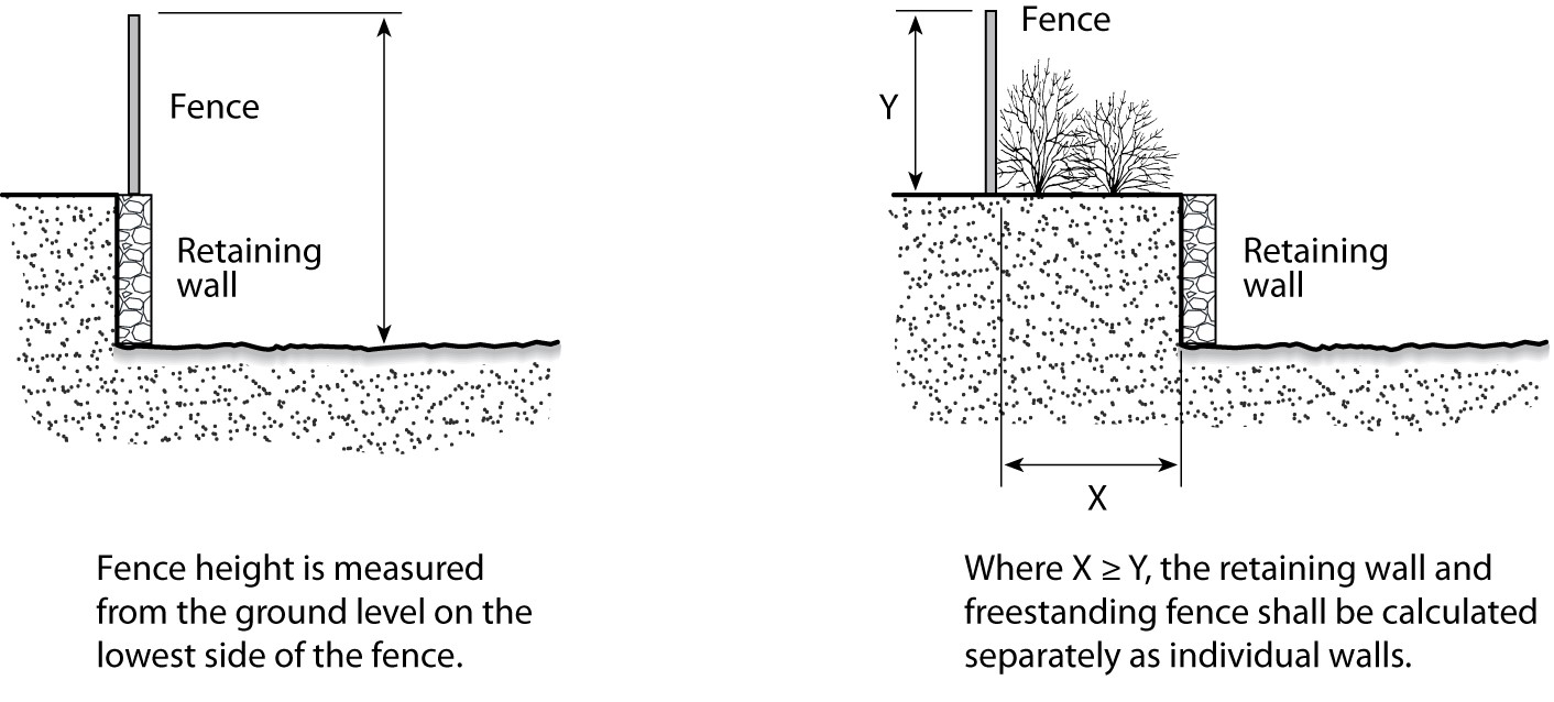
Figure 18.15.030.E. Measuring Height
3. Measuring Height of Antennas. The height of building-mounted antennas shall include the height of that portion of the building on which the antenna is mounted. In determining the height of portable “crank-up” or similar towers whose height is adjustable, the height of the tower shall be the maximum height to which it is capable of being raised.
F. Measuring Lot Width and Depth.
1. Lot Width.
a. For rectangular lots, lots having side lot lines not parallel, and lots on the outside of a curve of a street, the distance between the side lot lines is measured at the required minimum front yard setback line on a line parallel to the street or street chord.
b. For lots on the inside of the curve of a street, the distance between side lot lines is measured 30 feet behind the required minimum front yard setback line on a line parallel to the street or street chord.
2. Lot Depth. The horizontal length of a straight line connecting the midpoints of the front and rear lot lines; and for triangular shaped lots, the shortest horizontal distance between the front lot line and a line within the lot, parallel to and at a maximum distance from the front lot line, having a length of not less than 10 feet.
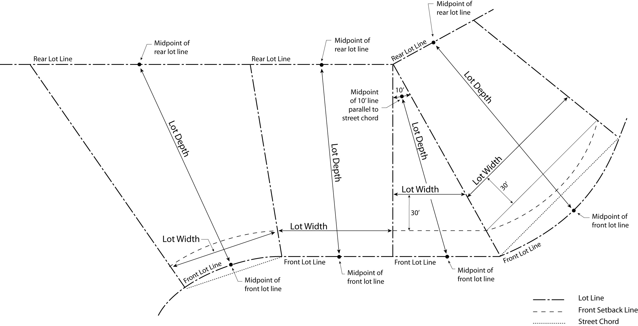
Figure 18.15.030.F. Measuring Width and Depth
G. Determining Floor Area. Floor area is the horizontal area (expressed in square feet) of all floors included within a building or buildings, according to the following rules:
1. Included in Floor Area. Floor area includes:
a. The floor of atrium and lobby areas;
b. Storage and equipment spaces that are roofed and enclosed on all sides;
c. Enclosed and roofed halls, stairways, and elevator shafts;
d. Enclosed and roofed porches and balconies;
e. Portions of basements and attics that meet the city’s building code height requirements for habitable space; and
f. The actual floor space of mezzanines, interior balconies, lofts, closets, and all habitable rooms.
2. Excluded from Floor Area. Floor area does not include:
a. Garages, parking shade structures or other areas used for parking and loading, or vehicular access to parking and loading spaces;
b. Unenclosed exterior balconies, decks, porches, and stairs; and
c. Substandard height portions of attics and basements not used as habitable space as defined by the building code.
H. Determining Floor Area Ratio. The floor area ratio (FAR) is the ratio of the floor area of all principal and accessory buildings on a lot to the lot area. To calculate FAR, floor area is divided by lot area, and typically expressed as a decimal. For example, if the floor area of all buildings on a lot totals 20,000 square feet, and the lot area is 10,000 square feet, the FAR is expressed as 2.0.
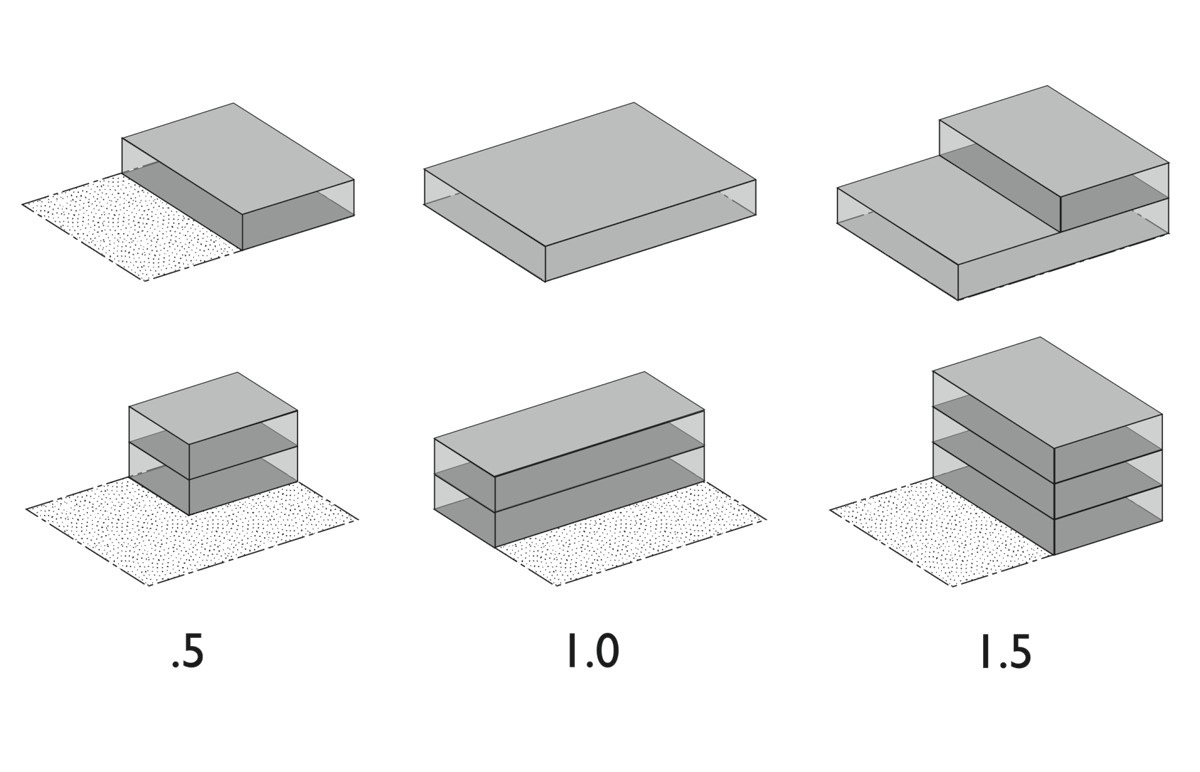
Figure 18.15.030.H. Determining Floor Area Ratio
I. Determining Lot Coverage. Lot coverage is the ratio of the total footprint area of all structures on a lot to the net lot area, typically expressed as a percentage. The footprints of all principal and accessory structures, including garages, carports, covered patios, and roofed porches, shall be summed in order to calculate lot coverage. The following structures are excluded from the calculation:
1. Unenclosed and unroofed decks, uncovered patio slab, porches, landings, and stairways less than 30 inches above grade;
2. Eaves and roof overhangs projecting up to two-and-one-half feet from a wall;
3. Trellises and similar vertical structures that do not have any type of roof or coverable feature;
4. Swimming pools and hot tubs that are not enclosed in roofed structures or decks; and
5. One nonhabitable accessory structure under 120 square feet and under seven feet high. Structures greater than quantity of one shall be included in lot coverage.
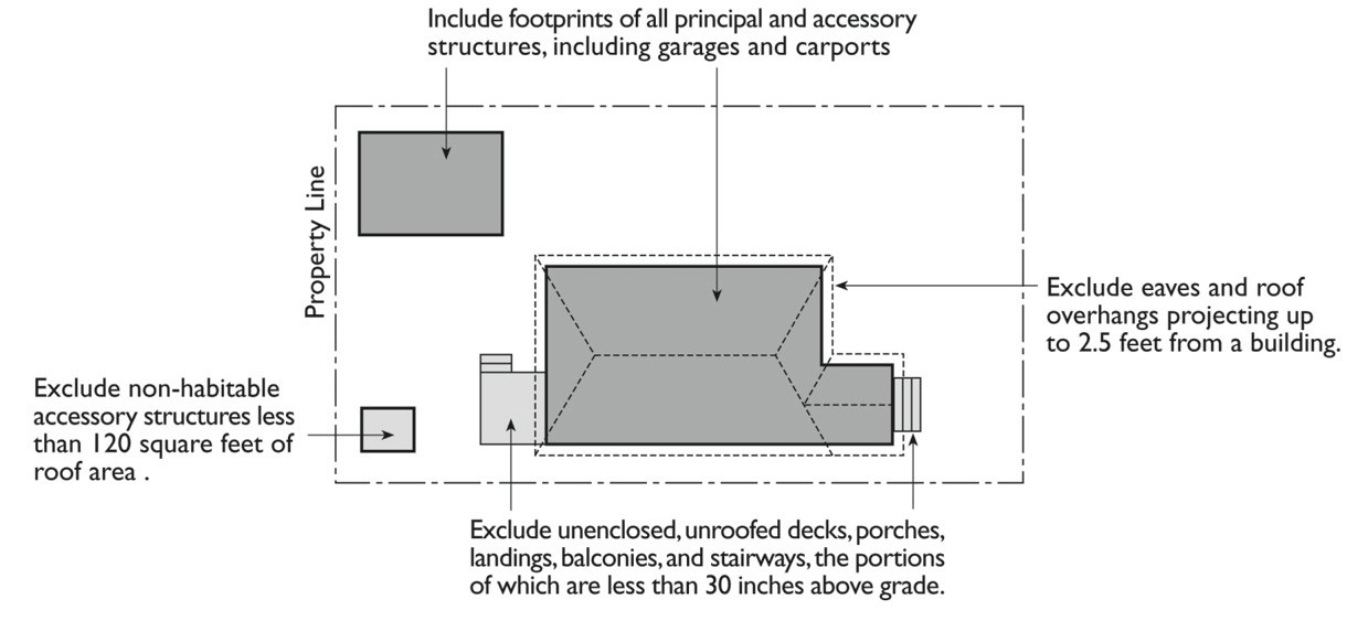
Figure 18.15.030.I. Determining Lot Coverage
J. Determining Lot Frontage.
1. Corner Lot. The front of a lot is the narrower dimension of the lot lines adjoining a street right-of-way. See also “Lot Line, Front” in Division 6, General Terms.
2. Through Lot (Double Frontage Lot). When a nonaccess easement does not exist, the front yard borders the street primarily used as frontage by neighboring lots.
K. Determining Setbacks for Yards. A setback line defining a required yard is parallel to and at the specified distance from the corresponding front, side, or rear lot line. The following special regulations for determining yards apply when a lot abuts a proposed street or alley:
1. Yards Abutting Planned Street Expansions. If a lot abuts an existing or proposed street for which the existing right-of-way is narrower than the right-of-way ultimately required for the street, the required setback shall be established from the future right-of-way rather than the lot line.
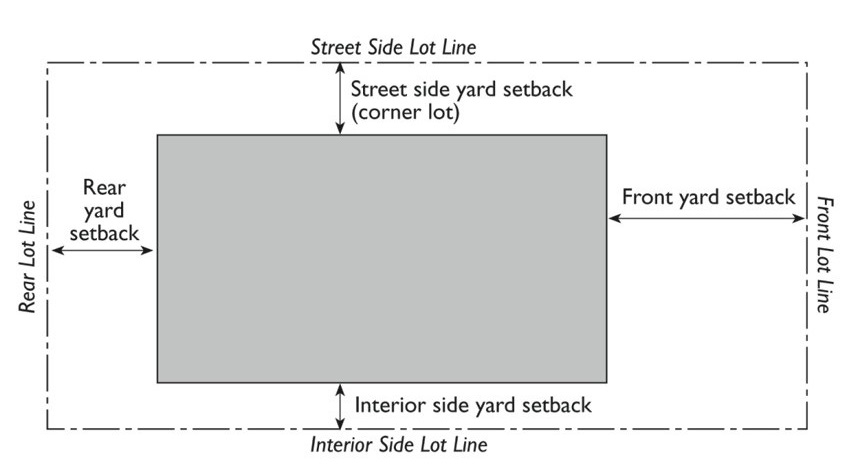
Figure 18.15.030.K. Determining Setbacks
2. Yards on Alleys.
a. If a side lot line abuts an alley, the yard shall be considered an interior side yard rather than a corner side yard.
b. In computing the minimum yard for any lot where such yard abuts an alley, no part of the width of the alley may be considered as part of the required yard.
L. Measuring Signs. The height of signs is measured in the same method as the height of other structures, refer to subsection (E)(2) of this section. Calculation of sign area is described in Chapter 18.115 MCC, Signs. [Ord. 14-12 § 1; Res. 14-36 § 103.03.]